NASHVILLE, Tenn. (WKRN) — As water levels continue to rise across the Cumberland River Basin, the U.S. Army Corps of Engineers’ (USACE) Nashville District said it has activated Level 1, which means the water management team is working around the clock to monitor conditions, adjust dam operations, and coordinate with emergency response agencies to reduce flood risks.
The USACE sent these current and estimated flood conditions shortly after 8:30 p.m. on Saturday, Feb. 15:
- Cumberland River at Nashville: “Forecast to crest just below minor flood stage at 39.7 feet. While below minor flood stage (40 ft), Riverfront Park will flood, and access points from Nissan Stadium will be inaccessible. Low-lying areas near the I-24 and I-65 bridges will also see flooding. Greenway areas will also be impacted and water begins to approach industrial properties on Adams St, Cement Plant Rd, Cowan St, Cowan Ct, and Davidson St.”
- Red River at Port Royal: “Expected to crest at 46.8 feet, which would be the third-highest flood crest on record since 1937 (compared to 49.5 ft in 2010 and 48.3 ft in 1975). Homes on Rivermont Dr, River Run, Idlewood Dr, and Wimbledon Ct may see floodwaters, and multiple roads could become impassable.”
- Cumberland River at Clarksville: “Expected to crest at 52 feet at midnight Sunday into Monday. Flooding will impact most agricultural and many commercial properties, Riverfront Park, and roads including South Riverside Dr, North Riverside Dr, Quarry Rd, Kraft St, and Zinc Plant Rd.”
- Cumberland River at Dover: “Expected to crest just above minor flood stage at 69.1 feet by noon Monday. Roads near the river will become impassable, and nearby farmland will flood.”
- Other areas of concern include Upper Cumberland (Williamsburg, Barbourville, Pineville, and Baxter), where additional flooding is expected. In addition, the Harpeth River near Kingston Springs is forecast to exceed the flood stage.
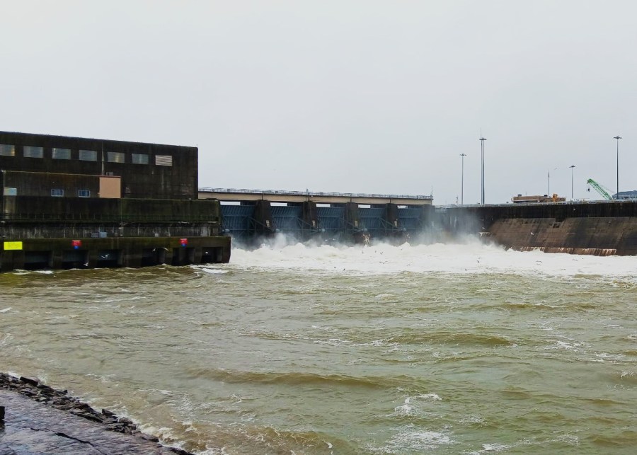
Officials said they have made several operational adjustments in order to manage flood risks and balance water levels:
- Barkley Dam: Spillway releases increased to 165,000 cubic feet per second (CFS) in coordination with the Tennessee Valley Authorities (TVA) and USACE
- Old Hickory Dam: Spillway releases increased to 85,000 CFS
- Cordell Hull Dam: Spillway releases increased to 52,000 CFS
- Cheatham Lock and Dam: Spillway gates removed clear of the water surface and project is currently in free flow, as is designed, releasing 112,000 CFS; navigation closed through at least Tuesday
- Center Hill, Wolf Creek, Dale Hollow, and J. Percy Priest Dams: No releases to limit downstream flooding
The USACE said it is holding back 325,000 CFS of water in its flood control reservoirs — Wolf Creek, Dale Hollow, Center Hill, and J. Percy Priest — to help reduce flood risks downstream. From noon to 6 p.m. Saturday, those reservoirs reportedly absorbed the full inflow without releasing any water, effectively removing 325,000 CFS from the Cumberland River system, which lowers river levels in flood-prone areas while allowing time for controlled releases once conditions improve.
Due to the current flood concerns, officials shared a reminder with the public about safety measures:
- Stay away from dam release areas. High flows create strong currents, sudden surges, and life-threatening conditions for boaters, anglers, and swimmers.
- Avoid tailwaters and floodgates where water is actively being released.
- Respect all warning signs and restricted areas near dams.
- Don’t try to navigate through high-flow areas. Those waters are extremely turbulent.
“Level 1 (24/7 Operations) is only activated in extreme conditions—such as significant rainfall, dam safety concerns, or major flood risks. This means the Corps is actively coordinating with federal, state, and local emergency agencies to mitigate risks and keep the public informed,” the USACE said in Saturday night’s statement. “While dams and reservoirs help regulate flooding, unregulated streams and tributaries can still rise quickly. Flash flooding remains a concern, and residents in flood-prone areas should stay alert and monitor local emergency alerts.”
Don’t forget to take the power and reliability of the WKRN Weather Authority with you at all times by downloading the News 2 Storm Tracker app.