NASHVILLE, Tenn. (WKRN) — The ground is already saturated from the 1-3 inches of rain received from this week, and with another 1-5 inches expected this weekend, the local rivers and creeks will have more flooding concerns that will persist into next week.
Some of the streams and rivers are expected to have flooding problems that may impact land and property.

The Cumberland River in Nashville is currently below flood stage (around 27 feet), but will rise to action stage by Saturday afternoon & evening. It will peak early Monday at about 36.70 feet, but to stay below the flood stage of 40 feet. Areas along the Nashville Riverfront and recreation areas near Nissan Stadium could flood at 37 feet, as well as access points along the river and portions of the Cumberland River Greenway.

Mill Creek in the Woodbine area of Nashville is expected to reach 15 feet early Sunday morning. The flood stage is 14 feet. Flooding of residential properties along Drummond Drive and the mobile home park on Philfre Court near Murfreesboro Pike begins. Flooding of property continues along Wimpole Drive, Currey Road, and at the intersection of Old Glenrose Ave and Thompson Ln.

Mill Creek at Antioch area is expected to peak near its flood stage of 14 feet, at 13.90 feet by early Sunday morning. Flooding will likely occur near Antioch Pike, Blue Hole Road, Franklin Limestone Road, Haywood Lane and Harding Place.

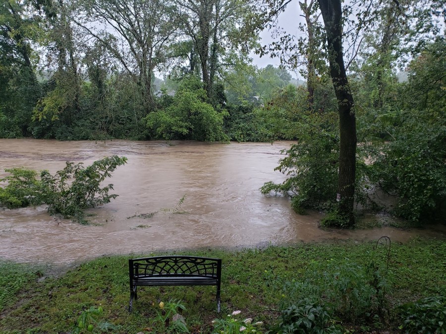
For the Harpeth River in Franklin, flood stage is 30 feet, and early Sunday morning the projected peak water level will be near 25 feet. At this water level, water covers portions of Lewisburg Pike between U.S. 431 and the Carnton Plantation which is impassable, as well as 3rd Ave N near the intersection with 4th Ave N, and approaches Cotton Ln near Fieldstone Pkwy, Del Rio Pike near Two Rivers Ln, and Old Natchez Trace near Temple Rd. Water continues to impact Franklin Bridge Golf Club, Cheekwood Golf Club, walking trails at Bicentennial Park, ballfields at Fieldstone Park, portions of The Park at Harlinsdale Farm, Lynwood Park, and Pinkerton Park. Water impacts the Franklin Bridge and Cheekwood Golf Clubs, Bicentennial Park, the ballfields at Fieldstone Park, The Park at Harlinsdale Farm, Lynwood Park, and Pinkerton Park. Lewisburg Pike, 3rd Ave N near the intersection with 4th Ave N, Cotton Ln near Fieldstone Pkwy, and Del Rio Pike near Two Rivers Ln are impassable.

In Bellevue (Nashville), the Harpeth River flood stage is at 20 feet, and the projected water level will be at 19.60 feet by early Sunday morning. Low lying areas along the river begin to be inundated, including portions of the Harpeth River Greenway, Moran Rd, Old Natchez Country Club golf course, Reese Smith Jr baseball fields, the parking lot at the Harpeth Valley Golf Center, the HYSA soccer complex, and Newsome Station Rd near the river which is impassable at higher levels. Areas along the river, including recreational facilities and the athletic fields at Ensworth High School, continue to be impacted by high water. Moran Rd and Newsome Station Rd are impassable, and water approaches Old Harding Pike near Morton Mill Rd which may be impassable at higher levels. Water also begins to impact properties adjacent to the river in the 7800 block of Hwy 100, and on Old Natchez Trace near Sneed Rd. Flooding along the river impacts many roads including Old Harding Pike near Morton Mill Rd, Morton Mill Rd between Northridge Dr and Bay Cove Trl, Moran Rd, and Newsome Station Rd. Water also begins to impact properties adjacent to the river in the 7800 block of Hwy 100, on Old Natchez Trace near Sneed Rd, and reaches the Ensworth High School athletic structures and facilities. Water approaches properties on Temple Rd south of Hwy 100.

The worst of the Harpeth River flooding could occur in Kingston Springs. Flood stage is 20 feet, and it is projected to reach near 25 feet by Sunday morning. Residences on Zapata Drive, Sawyer Farms Ln, Bluff View Drive, and Riverview Drive are being impacted by flooding, as well as U.S. 70 near Hwy 249, Walkup Rd near Sawyer Farms Ln, Riverview Drive near Elkmoore Drive, and Cedar Hill Rd near Griffintown Rd. Water approaches W Kingston Springs Rd at Big Turnbull Creek, and Cedar Hill Rd at Pickards Rd which may be impassable at higher levels.

One area of major flooding concern is Montgomery County at the Red River near Port Royal. Flood stage is 30 feet, but the water is projected to rise to over 40 feet on Sunday. Significant flooding continues to affect areas along the river, including the Red River Valley Park, Port Royal Rd near Hwy 238, Dunbar Cave Rd just west of Warfield Blvd which is covered with water, and portions of the Swan Lake Golf Course. Water could approach homes on Rivermont Drive, River Run, Idlewood Drive, and Wimbledon Court, and approach yards of homes on Colin Ct, E Accipiter Cir, Pond Apple Rd, Foxfire Rd, Hay Market Rd, and Riverhaven Drive. Roads are also impacted and impassable, including Port Royal Rd near Hwy 238 and Dunbar Cave Rd just west of Warfield Blvd.

Staying in Montgomery County, the Cumberland River in Clarksville is projected to reach moderate flood stage at 50 feet by Monday morning. Flood stage is 46 feet. Most agricultural areas along the river are flooded, as well as many industrial and commercial properties, Riverfront Park, and adjacent tributaries. Riverside Drive in Clarksville begins to flood near TN-48, Providence Blvd, Mc Clure St, and Cumberland Dr. Also impacted are locations near Quarry Rd, Kraft St near College St and Providence Blvd, Zinc Plant Rd, Salem Rd, and Seven Mile Ferry Rd. Water approaches athletic fields near Greenland Farms Dr, and properties on Branch Rd.
Don’t forget to take the power and reliability of the WKRN Weather Authority with you at all times by downloading the News 2 Storm Tracker app.